How Accurate Is Phone Location Tracking? GPS, Wi-Fi and Cell Compared
 By TheTruthSpy Editor · Founder and editorPublished September 19, 2026Updated September 21, 20269 min read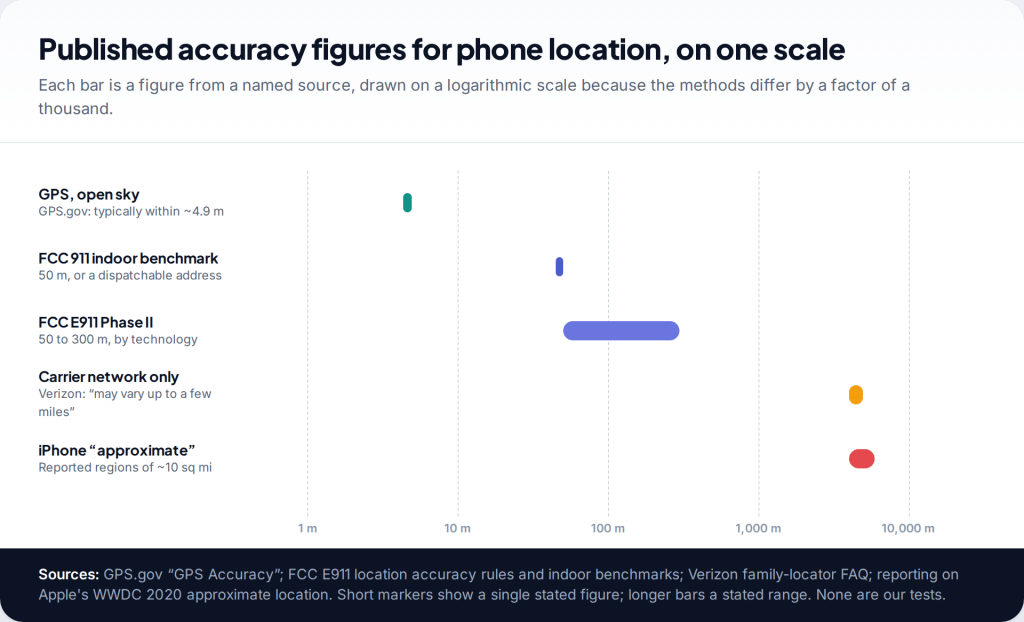
Phone location accuracy depends on which signals the phone can use. Under open sky, GPS on a smartphone is typically accurate to within about 4.9 metres, according to the US government’s GPS.gov. Indoors, phones lean on Wi-Fi and mobile masts and the error grows. When only the mobile network is used, estimates can be off by miles. Every location comes with an accuracy circle that tells you which case you are looking at.
- GPS outdoors: a few metres, per GPS.gov, degraded by buildings, trees and reflections.
- Wi-Fi indoors: good enough for the building in most towns, less reliable for the room. Published figures vary too much to quote one.
- Mobile network alone: coarse. One carrier says its network-only family location “may vary up to a few miles”.
- Read the circle, and the timestamp. A wide circle or an old update means an area, not an address.
Phone location accuracy at a glance
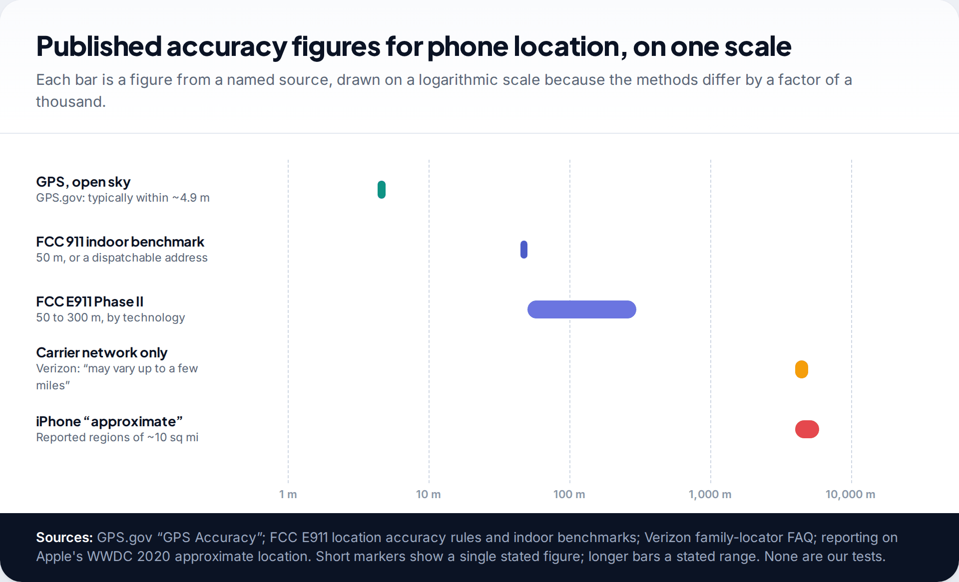
There isn’t one accuracy figure for phone location, because a phone uses several methods and switches between them constantly. What does exist is a handful of published figures from credible sources, and they span three orders of magnitude.
At the precise end, GPS.gov says GPS-enabled smartphones are typically accurate to within a 4.9-metre radius under open sky. In the middle, the US Federal Communications Commission requires carriers to locate 911 callers within 50 metres, or provide a street address, for most calls. At the coarse end, Verizon’s own help pages say its family locator, without its app on the child’s phone, shows an approximate network location that may vary by up to a few miles. And when an iPhone app is given only approximate location, reporting on Apple’s 2020 announcement described regions of about ten square miles.
We have deliberately not drawn a bar for Wi-Fi positioning. Studies report very different figures depending on how dense the networks are, and we couldn’t find one authoritative number to cite.
How a phone works out where it is
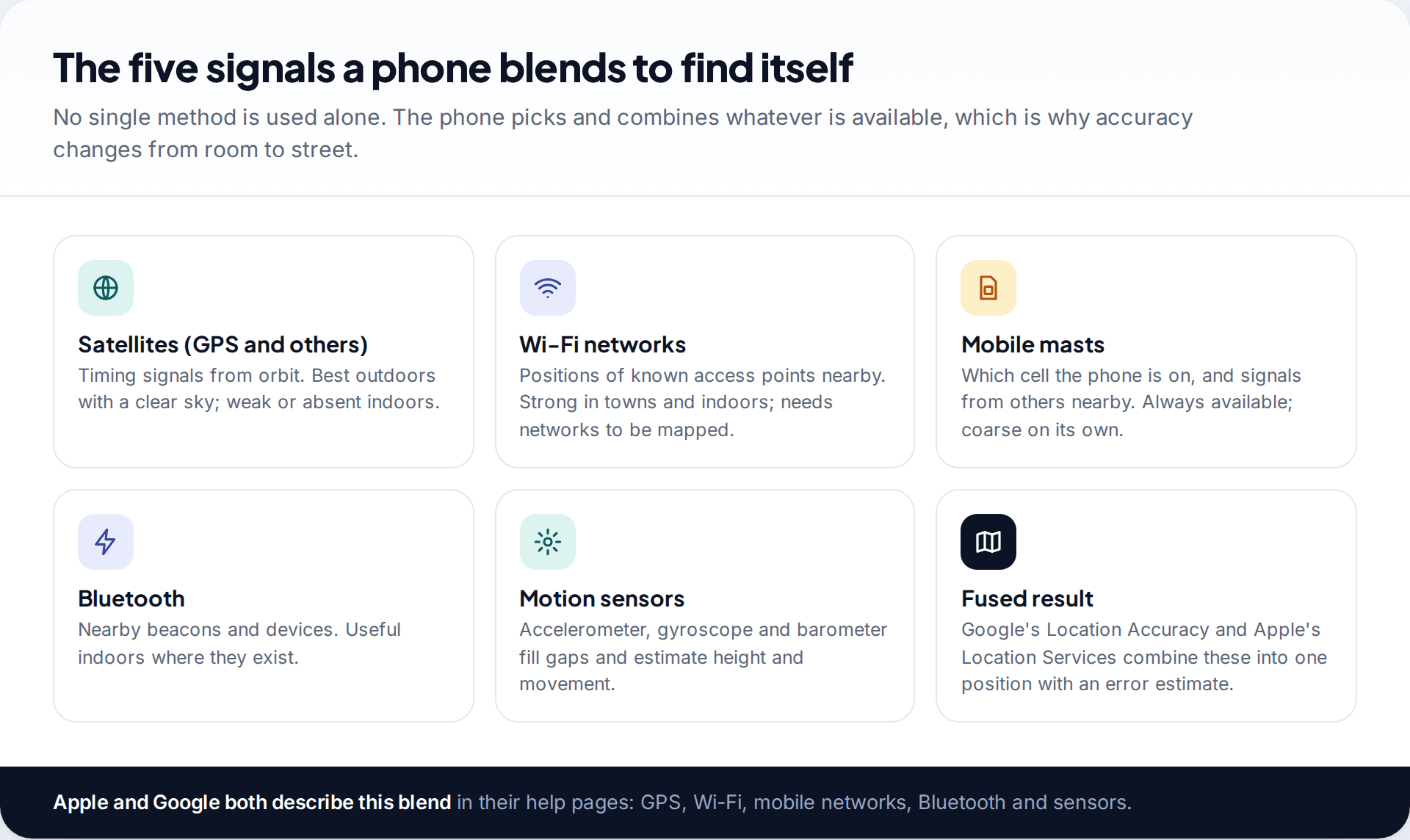
Satellites. The phone listens for timing signals from GPS and other satellite systems and calculates its distance from each. Out in the open this is the most accurate method. The signals are weak, though, and roofs, walls and even dense tree cover degrade them.
Wi-Fi. Google and Apple maintain databases of where Wi-Fi access points are. A phone that can see several known networks can place itself without satellites, which is why it can find you inside a shopping centre. Apple describes this as using crowd-sourced Wi-Fi hotspots. It works best where there are lots of networks, and poorly in the countryside.
Mobile masts. The network always knows which cell the phone is using, and the phone can measure signals from several masts. On its own this is the coarsest method, especially in rural areas where cells are large, but it is always available when there is signal.
Bluetooth and sensors. Bluetooth beacons help in some buildings. Accelerometers and gyroscopes track movement between fixes, and a barometer can estimate height, which is what makes floor-level location possible. Google’s help page for Location Accuracy lists all of these as inputs, and turning that setting off leaves only GPS and sensors.
What the accuracy circle means
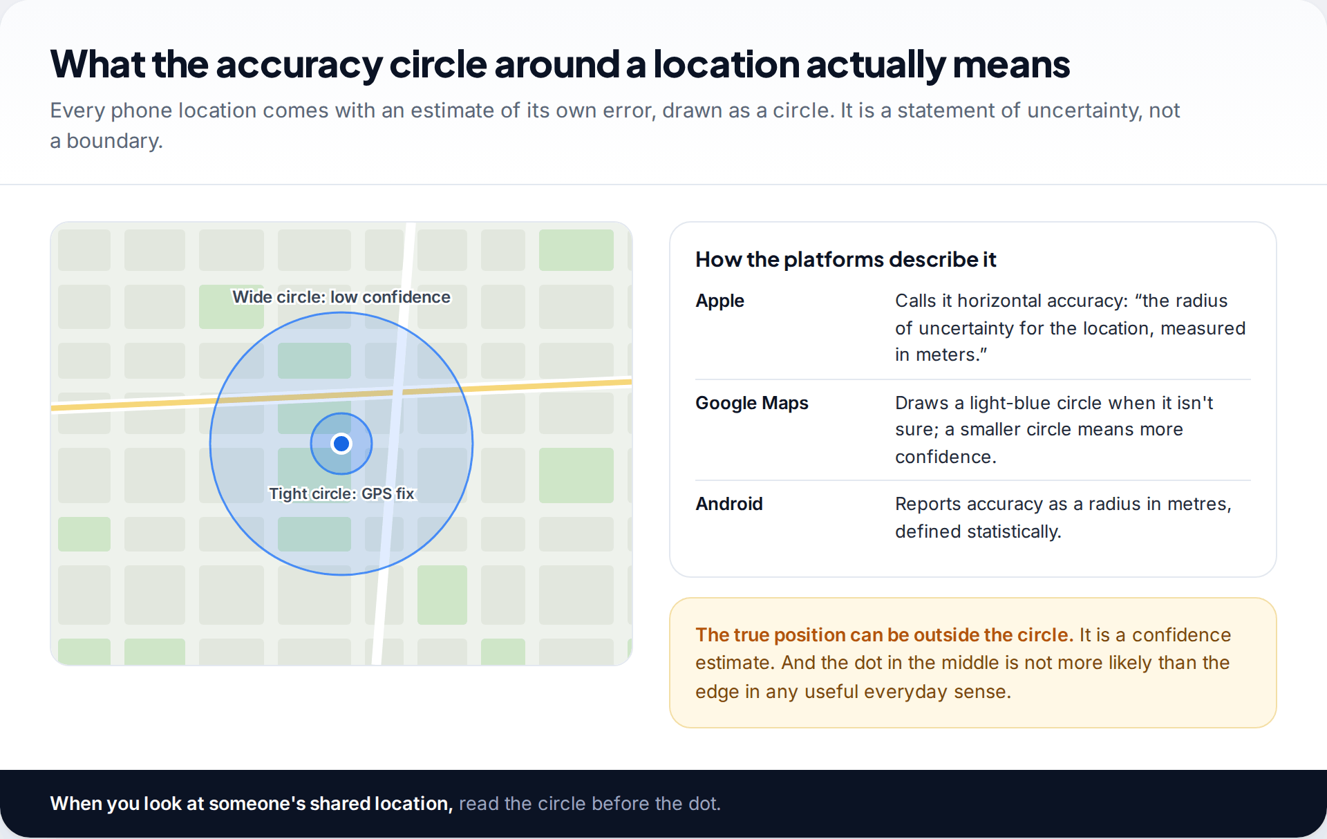
Every location a phone produces carries an estimate of its own error, usually called horizontal accuracy and drawn as a circle. Apple’s developer documentation defines it as “the radius of uncertainty for the location, measured in meters”. Google Maps shows it as the light-blue circle around the blue dot and says a smaller circle means Maps is more confident.
Two points are easy to miss. The circle is statistical, so the true position is usually but not always inside it. And the dot at the centre isn’t a precise answer with a bit of wobble — when the circle is large, anywhere inside it is plausible. When you look at a family member’s location and the circle covers three houses, the app is telling you it doesn’t know which one.
Indoors versus outdoors
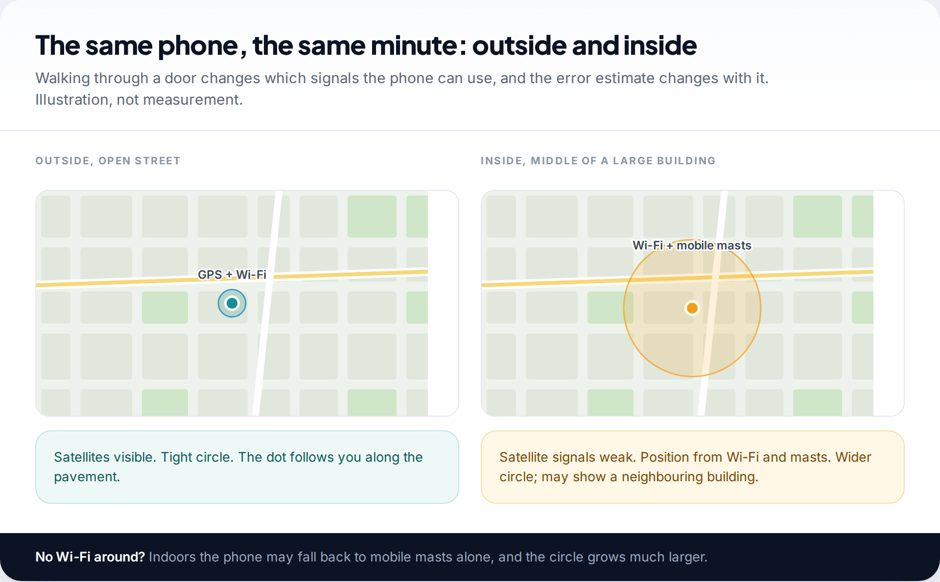
The biggest single change in accuracy happens at the front door. Outside, the phone can see satellites and gets a tight fix. Inside, satellite signals are much weaker and the phone relies more on Wi-Fi and masts. In a home or office with plenty of nearby networks, that usually still identifies the building. In a large building, a basement or somewhere with few networks, it may not.
That is why 911 rules focus on indoor calls. Most emergency calls come from buildings, and a fix good enough for a street isn’t good enough to find a flat.
Cities, reflections and the wrong side of the road
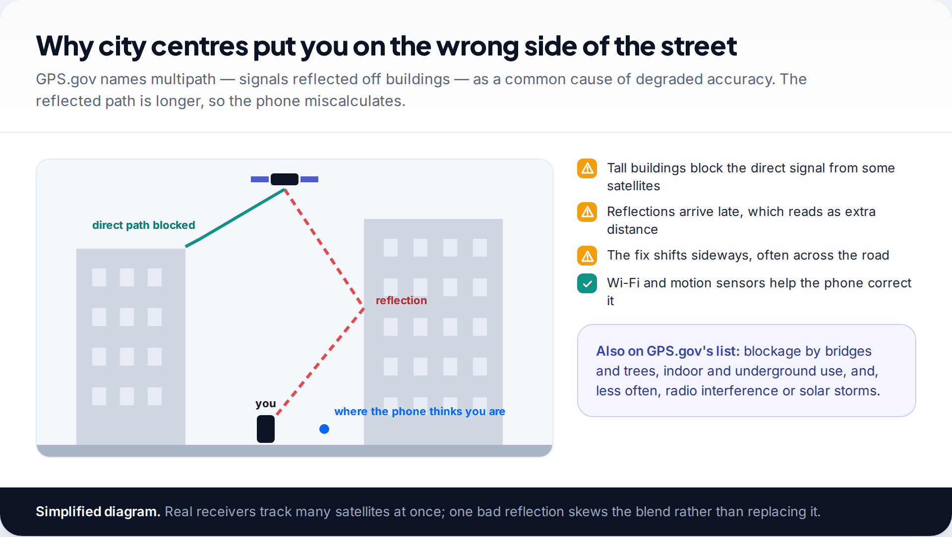
GPS.gov lists the common causes of degraded GPS accuracy: satellite signals blocked by buildings, bridges and trees, indoor or underground use, and signals reflected off buildings or walls, known as multipath. In a city centre all three happen at once. A reflected signal travels a longer path than a direct one, so the phone thinks that satellite is further away, and its calculated position slides — often across the street.
Modern phones soften this by blending in Wi-Fi and sensor data, but they can’t eliminate it. If a map shows you walking through buildings in a city centre, that is multipath, not a faulty phone.
Emergency calls: the accuracy regulators require
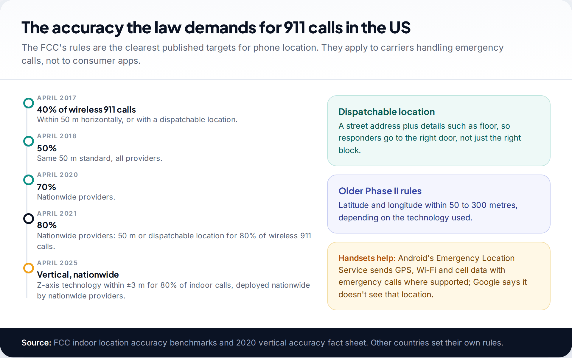
The most rigorous published standards for phone location come from emergency calling. The FCC’s indoor benchmarks required providers to deliver either 50-metre horizontal accuracy or a dispatchable location — a street address plus details like floor — for a rising share of wireless 911 calls: 40 percent by April 2017, rising to 80 percent for nationwide providers by April 2021. For height, the FCC adopted a vertical accuracy metric of plus or minus 3 metres for 80 percent of indoor calls, with nationwide deployment due by April 2025.
Handsets now contribute much of this. Android’s Emergency Location Service sends location from GPS, Wi-Fi, mobile networks and sensors directly to emergency services’ partners in supported countries. These rules apply to carriers and emergency calls, not to consumer apps, but they show what is achievable when the phone does the work.
Reading a shared location without overreacting
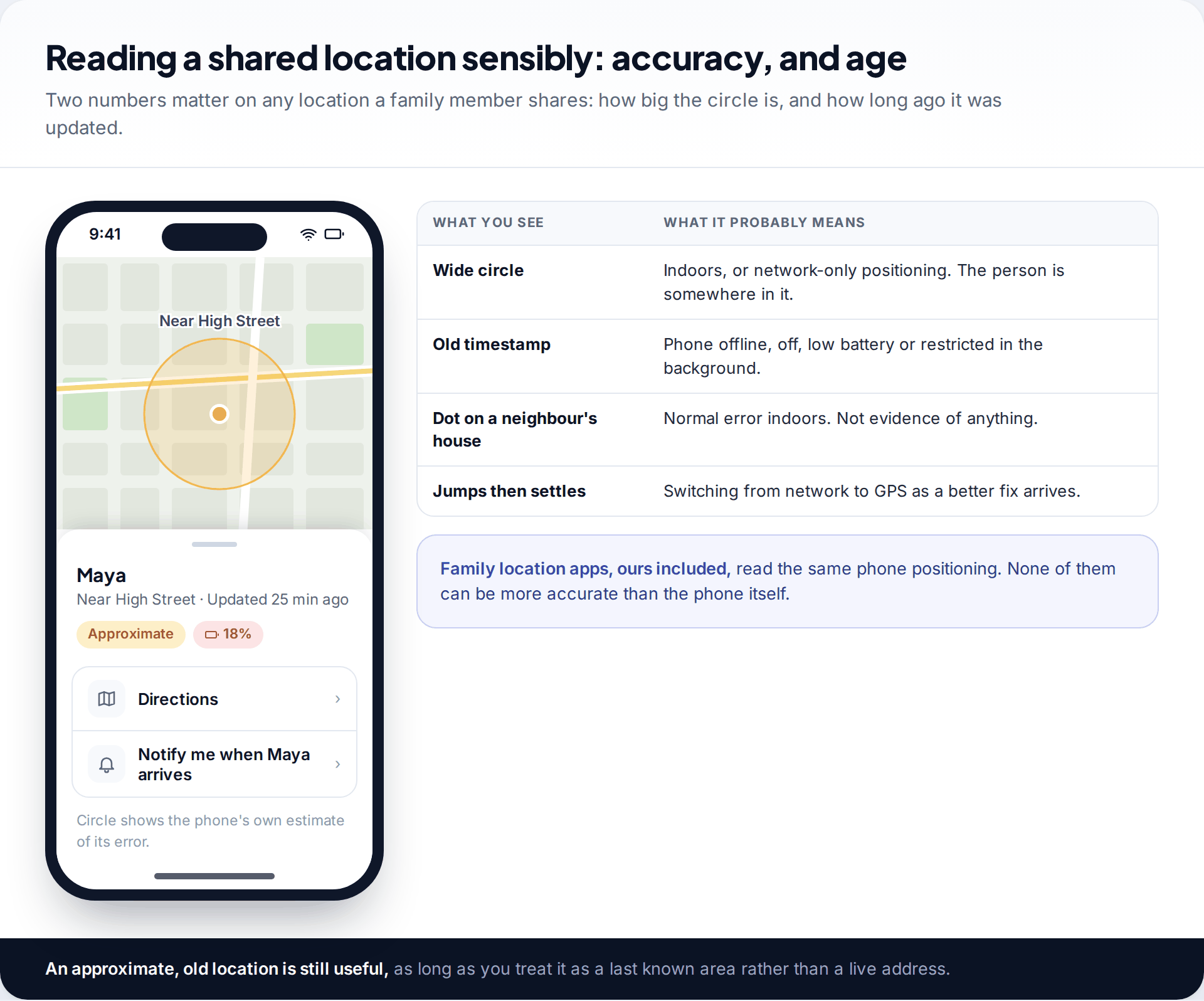
For families who share locations, accuracy matters most when something looks odd. A dot on a neighbour’s house, a jump across town and back, or a location that hasn’t changed for an hour all have ordinary explanations: indoor error, a switch from network to GPS, or a phone that is offline, flat or restricted by a battery saver. Look at the size of the circle and the time of the last update before worrying.
Family location apps all read the same positioning from the phone, so none of them can be more accurate than the phone itself. That includes our own location feature, which shows the phone’s reported position and its age, and has the same limits indoors, underground and when the phone is off.
Lost phones: how accurate is a last known location?
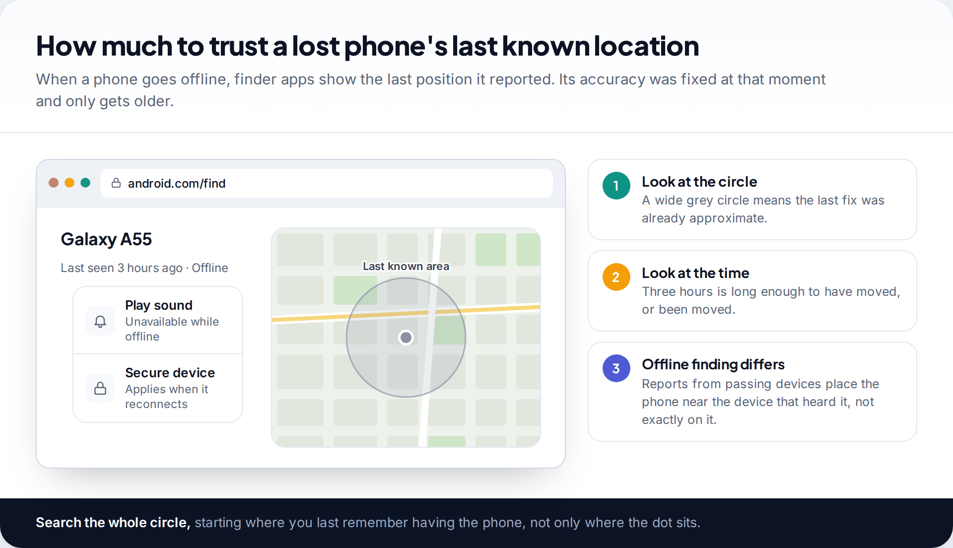
Finder services such as Find Hub and Find My show where a phone was when it last reported. If it went offline indoors, that last fix may already have been approximate, and the older it gets, the less it tells you about where the phone is now. Read the circle and the timestamp exactly as you would for a shared location.
Offline finding networks add another layer. Google’s Find Hub and Apple’s Find My can locate some phones that are offline, using other people’s devices that pass nearby and report them. The location reported is effectively the position of the device that heard your phone, so it places your phone in the vicinity rather than on a precise spot. Search the whole area, starting with where you last remember having it.
Common misconceptions about location accuracy
- “Flight mode turns off GPS.” GPS is receive-only, and many phones keep location working in flight mode. Without data, though, maps may not load and assisted GPS can’t speed up the first fix.
- “The dot is where the person is.” The dot is the centre of an estimate. With a wide circle, it is no more likely to be right than the edge of the circle.
- “A newer phone is always more accurate.” Newer hardware helps, but surroundings and settings matter more. The same phone varies more between street and basement than between models.
- “A live location is always live.” Sharing apps update on their own schedule and can be paused by battery savers. Always check the update time.
- “Anyone can pinpoint a phone from its number.” Only the carrier holds network location, and it releases it for emergency calls or under legal process.
What affects the accuracy you get
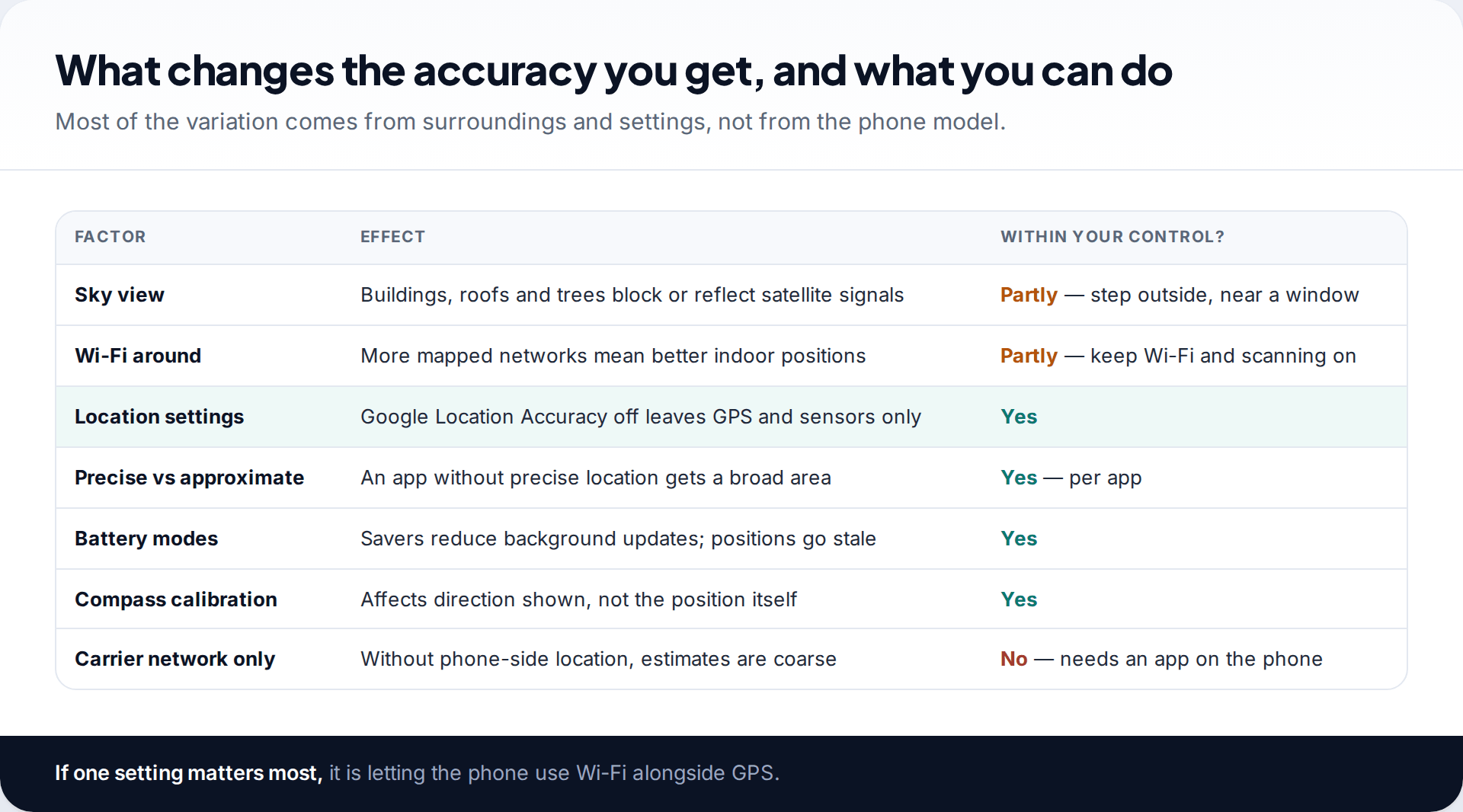
Some of this you can influence. Keep Wi-Fi and Wi-Fi scanning on, leave Google Location Accuracy on if you are comfortable with the data it sends to Google, give apps that need it precise location, and stop battery savers restricting apps you rely on. Our guide to improving GPS accuracy on your phone goes through each setting. What you can’t change is the physics: roofs, walls and tall buildings will always cost some accuracy.
How this page was put together
We used published figures only, each attributed where it appears: GPS.gov’s accuracy page, the FCC’s E911 location accuracy rules and indoor benchmarks, Verizon’s family locator FAQ, Apple’s and Google’s developer and help documentation, and contemporary reporting on Apple’s approximate location feature. We checked them in September 2026. We did not run our own accuracy tests, and the indoor and outdoor diagrams are illustrations rather than measurements.
Where no single reliable figure exists, as for Wi-Fi positioning, we’ve said so rather than pick one. Our approach to sources and corrections is published.
Common questions
How accurate is phone GPS?
GPS.gov says GPS-enabled smartphones are typically accurate to within about 4.9 metres under open sky. Buildings, trees and indoor use make it worse.
How accurate is location from cell towers?
Much coarser than GPS, especially in rural areas with large cells. Verizon, for example, says its network-only family location may vary by up to a few miles.
Is Wi-Fi location accurate?
Often good enough to identify a building in towns with many networks, less so in rural areas. Accuracy depends on how many known networks are nearby.
Why does my location show a neighbour’s house?
Indoors, the phone relies more on Wi-Fi and masts and the error grows. Check the accuracy circle: if it covers several houses, the phone can’t tell which one.
Can phone location tell which floor I’m on?
Sometimes. Phones with barometers can estimate height, and US emergency rules now include a vertical accuracy standard of plus or minus 3 metres for most indoor 911 calls.
Is one location app more accurate than another?
Not in any fundamental way. Find My, Google Maps, Family Link and other apps all read the position the phone calculates. Differences usually come from permissions, such as precise versus approximate location, and from how often each app updates.
Why does a shared location lag behind?
The phone may be offline, low on battery, or restricted by a battery saver, so updates arrive late. Check when it was last updated.
Looking for a tool to go with this? TheTruthSpy is a free parental control app for Android that stays visible on the child's phone. If it fits your family, see the Location & geofencing feature.
Related guides

Using Google Maps Timeline to Find a Lost Phone
Can Google Maps find a lost phone? Only in two cases: someone you share your location with can see it,…
GPS Tracking for Small Business: A Starter Guide
A plain starter guide to GPS tracking for a small business: vehicle trackers versus phone apps, what a small fleet…
Location Sharing on Android: Google Maps, Find Hub and Family Link
How location sharing on Android works: one Google Location Sharing setting behind Google Maps, Find Hub and Family Link, how…
Parental controls your child can see
Location, screen time limits, a web filter and alerts from notifications — free, and visible on your child's phone. Pair a phone in about ten minutes.
Android · Free to set up · Visible on your child's phone